
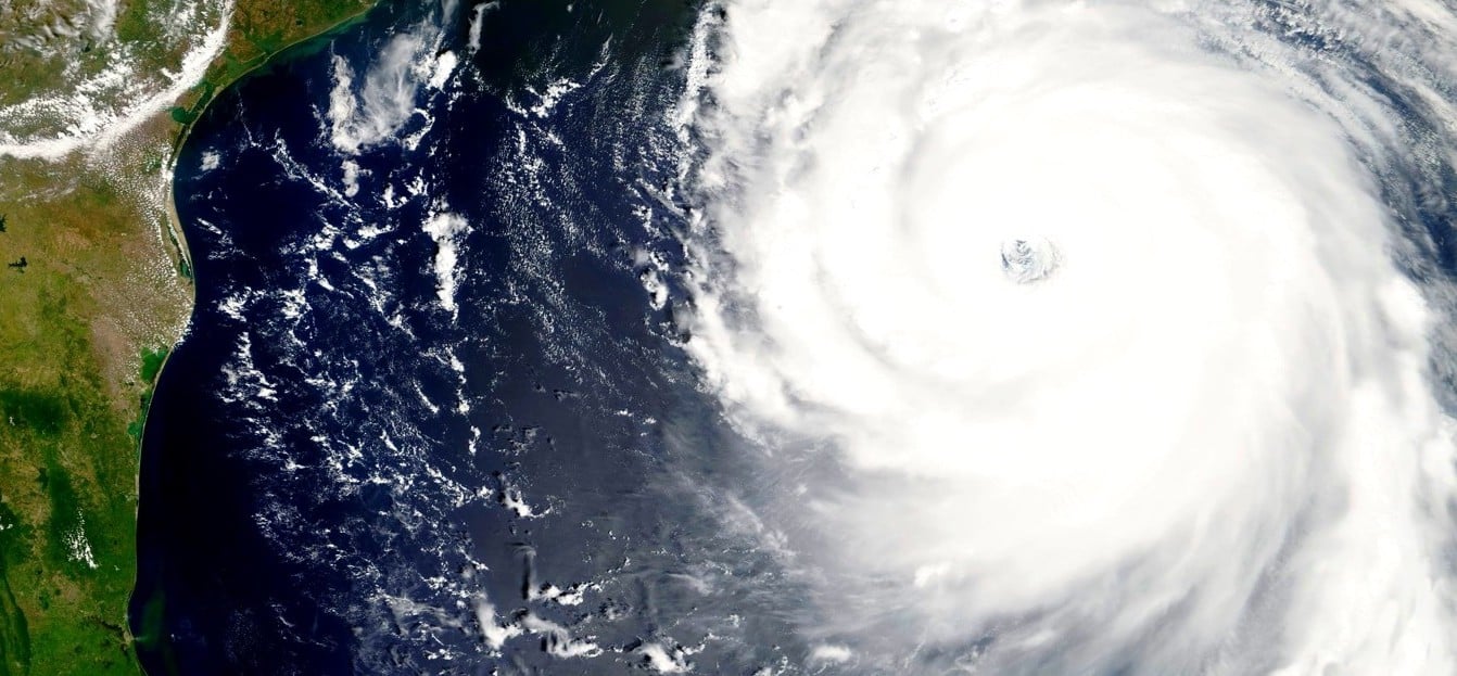
Alors que la plupart des experts prévoient une nouvelle saison de grosses tempêtes dans la région atlantique, 2022 s'annonce comme une année qui marquera les annales. Les prévisions actuelles d'ouragans en 2022 de l'Université d'État du Colorado annoncent une saison d'ouragans avec pas moins de 20 tempêtes nommées, y compris 10 ouragans, dont cinq pourraient atteindre les catégories 3, 4 ou 5 (c'est-à-dire des tempêtes majeures) ou de forte intensité sur l'échelle de Saffir-Simpson mesurant la puissance du vent des ouragans.
Probabilité d'au moins un ouragan de catégorie 3, 4 ou 5 aux États-Unis :
- Entire continental U.S. coastline = 76% (average for last century is 52%)
- Côte Est des États-Unis, y compris la péninsule de la Floride = 51 % (la moyenne du siècle dernier est de 31 %)
- Gulf Coast from the Florida Panhandle westward to Brownsville, Texas = 50% (average for last century is 30%)
The Atlantic hurricane season takes place between June 1 and November 30. If reality lives up to the preseason expectations, residents of these coastal regions could be looking at a very stormy season. When disaster might strike, knowing what to expect can make a world of difference. Discover what our professionals have to say about what to expect this hurricane season, what necessary precautions are recommended, and how to ensure a swift recovery.
La Niña Likely
The likelihood of a La Niña is relatively high this summer. It looks like it will affect worldwide weather patterns and likely cause more Atlantic Ocean hurricanes.
La Niña is characterized by cooler than normal water in the eastern and central tropical Pacific and is associated with strong winds near the ocean surface (trade winds), that cause cold water from the ocean’s depths to be brought to the surface in a process known as upwelling. When La Niña occurs, winds high up in the atmosphere in the tropical Atlantic and Caribbean tend to be weaker. Strong upper-level winds tear apart hurricanes, while weaker winds (as expected this summer), favor hurricane development and intensification.
Warmer Ocean Waters in the Atlantic
Indépendamment de La Niña, les températures de surface de l’autre côté de l’Atlantique sont actuellement plus chaudes que la normale. Il est important de surveiller les températures de surface de la mer au cours de la première moitié de l’été, car l’eau plus chaude fournit plus de carburant pour le développement des cyclones dans l’Atlantique tropical et les Caraïbes – où se forment la plupart des ouragans violents – plus tard dans l’année. En général, lorsque l’Atlantique tropical est plus chaud que la normale en juillet, il a également tendance à être plus chaud en août-octobre, qui sont les trois mois de pointe de la saison des ouragans de l’Atlantique. Ces anomalies à la surface de la mer peuvent certainement changer au cours des prochains mois, mais si elles persistent, elles fourniront le carburant idéal pour le développement de tempêtes.
Suivi d'une saison cyclonique orageuse dans l'Atlantique
The Colorado State University Meteorology Project team predicts there will be 20 named storms (tropical storms with 39 mile-per-hour winds or higher) in 2022. Of those, the team expects 10 will become hurricanes and five will become major hurricanes (hurricanes with 111 mile-per-hour winds or higher). These hurricane predictions place the likelihood of hurricane activity in 2022 at about 145 percent of the average season. By comparison, the average Atlantic hurricane season during 1991-2020 was 14.4 named storms and 7.2 hurricanes.
Forecast Parameters Forecast for 2022 Average for 1991-2020
Named Storms 20 14.4
Named Storm Days 95 69.4
Hurricanes 10 7.2
Hurricane Days 40 27.0
Major Hurricanes 5 3.2
Major Hurricane Days 11 7.4
Canadian Hurricane Impacts
While the strongest effects of hurricanes are largely felt in the Gulf of Mexico and along the Eastern seaboard of the United States, Canada can also be impacted by significant storms, such as Juan in 2003 and Igor in 2010. Last year, Hurricane Larry struck Newfoundland as a Category 1 hurricane, causing power outages and damaging structures.
Hurricanes thrive in environments with warm ocean temperatures, high levels of moisture and low wind shear (the change in wind direction and speed with height in the atmosphere). When hurricanes move northward along the U.S.’s East Coast, they typically weaken as they encounter colder water, less moisture and higher shear. However, as noted above, these storms can survive and reach Canada if waters are warmer than normal, moisture is greater than normal and shear is lower than normal. Since the 2022 Atlantic hurricane season is forecast to be above normal, this historically has increased the odds of hurricane impacts for Canada as well.
Is Canada is Going to Have a Busy Hurricane Season?
On a seasonal timescale, experts unfortunately don’t have the ability to tell the direction in which a storm is going to track. The path of any given hurricane is dictated by day to day weather patterns, and the weather in mid-latitude regions fluctuates tremendously on a daily to weekly timescale. So, because of these fluctuations, it is hard to say where a storm would likely track before it even forms. But when a storm does form, understanding where it starts can help experts predict where it is headed. Also, once a storm actually forms, experts can generally predict with reasonable accuracy where the storm is likely to track for the next 3-5 days.
For example, when a storm forms off of the coast of Africa, the odds of that storm tracking all the way to the Gulf of Mexico are fairly low. That same storm has a higher likelihood of impacting the Eastern seaboard of North America, and if conditions are conducive, potentially bringing bigger impacts to the Northeast United States and the Atlantic providences of Canada.
Hurricane Activity in the Pacific
If there is a silver lining to all of this, it’s that when weather conditions are favorable for hurricane formation in the Atlantic Ocean, they typically are un-favorable for hurricane formation in the Pacific Ocean. For example, when a La Niña is present, as it is expected to be this summer, the overall atmospheric circulation becomes more favorable for Atlantic hurricanes but tends to suppress Pacific hurricane activity.
This overall presence of La Niña leads experts to believe that this summer will see less-than-normal amounts of hurricane activity in the Pacific Ocean. That said, while the likelihood is likely to be lower than normal, it only takes one storm making landfall to cause devastation.
How Can We Predict Hurricanes?
While historically the ability to predict hurricane activity was an inexact science, in the recent decades, the accuracy of seasonal forecasting has steadily improved. Scientists are now capable of calculating the likelihood of hurricanes developing in any given year with considerable precision due to a combination of more readily available historical data, improved understanding of storms and how they develop, adoption of improved statistical/dynamical models, and a detailed understanding of the oceanic and atmospheric conditions that preceded previous hurricanes.
How Accurate Are Hurricane Predictions?
Alors que les prévisionnistes disposent aujourd'hui d'outils plus fiables que jamais pour prévoir, diagnostiquer et suivre les tempêtes, il est important de noter que ces prévisions saisonnières sont basées sur des modèles inexacts. Par exemple, en moyenne, les prévisions de juin de l'Université d'État du Colorado sont considérées comme exactes à deux ouragans près. En 2022, l'Université d'État du Colorado prévoit 10 ouragans, ce qui signifie que la valeur observée sera probablement de 8à 12 ouragans.
De plus, les scientifiques ne sont toujours pas en mesure de prévoir la trajectoire exacte des tempêtes des mois à l'avance et ne peuvent fournir qu'une estimation précise de l'intensité relative des tempêtes, et non une mesure exacte. Ces informations sont tout de même précieuses pour les habitants de la côte qui ont hâte de préparer la saison à venir.
What Does It Mean for Coastal Residents?
Quelle que soit l'activité annuelle, il est essentiel de se rappeler qu'en toute saison, de nombreux résidents canadiens ne ressentiront pas les effets d'un ouragan. Mais il est également prudent de se rappeler qu'il suffit d'une tempête pour infliger de sérieux dégâts. Alors que les saisons plus actives connaissent généralement davantage d'ouragans qui touchent terre, une (ou plusieurs) fortes tempêtes peuvent toucher terre au cours de saisons d'ouragans par ailleurs calmes.
Qu'est-ce qui rend un ouragan mortel?
Storm Surge
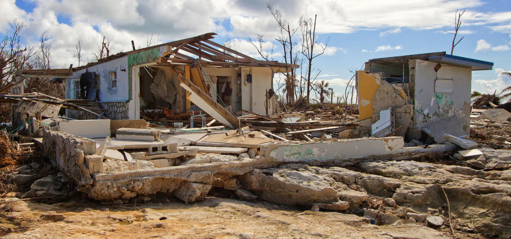
One of the greatest threats posed by a landfalling hurricane is storm surge, or the increase in seawater level during a hurricane. Storm surges can be unbelievably deadly, and often lead to destructive flooding that can persist for hours or even days after the storm has passed. Large battering waves and the accompanying flooding can result in loss of life, destruction of property, and extensive erosion of beaches and coastal environments.
Heavy Rain
The amount of rain generated in a hurricane isn’t directly related to the hurricane’s strength, but rather the speed it travels, its size, and the geography where it lands. When heavy rain from a hurricane hits land, it often causes flash flooding of rivers and streams and, like the flooding produced by storm surge, this flooding can last for days after the storm itself has passed.
Hurricane-Force Winds
Les vents d'une force supérieure à celle d'un ouragan (74 mi/h ou plus) constituent une autre menace mortelle. Les vents de la force d'un ouragan peuvent facilement détruire des biens, arracher des arbres du sol et transformer des débris tels que des panneaux, des toitures, des bardages et d'autres articles en missiles aériens. Les vents peuvent conserver leur force d'ouragan même plusieurs heures après qu'un ouragan ait touché terre.
Tornadoes
Hurricanes can also spawn tornadoes when they come onshore. The friction that is generated when a hurricane makes landfall reduces winds near the surface, while winds higher up in the atmosphere remain strong. This creates a horizontal spin in the atmosphere, which can be then converted into vertical spin when it encounters a thunderstorm updraft. This vertical spin can sometimes lead to tornadoes, which can subsequently cause extreme wind damage.
Steps to Take Before the Storm
When staring down a hurricane, every second counts. Thankfully, there are some easy ways property owners can prepare for the upcoming storm season.
- Connect with a restoration partner to customize a pre-loss action plan and determine how to react should disaster strike. Devising a pre-hurricane plan is the most crucial precaution a property owner should take before disaster.
- Develop an Emergency Access Letter and Master Service Agreement so service providers can access the facility and restoration contractors can begin remediation work as quickly as possible.
- Prepare the property by making sure emergency supplies are in place, fuel tanks are full, equipment is covered, critical documents protected, data systems backed up, and evacuation routes and procedures are in place.
- Communicate the evacuation plan with employees and other residents to ensure everyone knows routes and procedures.
- Give critical contact info and directions to suppliers, vendors, and other partners so there aren’t any lapses in communication when time is of the essence.
- Déterminez si une alimentation temporaire ou une installation temporaire est nécessaire pour réduire le temps d'interruption des activités.
- Provide instructions for shutting off water, power, and gas lines so any employee authorized can do so before the storm.
- Determine security needs such as camera monitoring, physical security, fencing, or boards for windows and doors.
- Track the weather and stay alert. Storms can move fast, so it’s important to stay updated on the latest conditions. Safety is more important than any property, so be sure to leave enough time to get out of harm’s way.
Partager ceci :


