

With another big Atlantic storm season in most experts’ forecasts, 2022 is shaping up to be one for the record books. Current 2022 hurricane predictions from Colorado State University say the Atlantic hurricane season could see 20 named storms, including 10 hurricanes, with five potentially reaching Category 3, 4, or 5 (i.e., major) intensity on the Saffir-Simpson Hurricane Wind Scale.
Probability of at least one Category 3, 4, or 5 hurricane making landfall in the United States:
- Entire continental U.S. coastline = 76% (average for last century is 52%)
- U.S. East Coast, including Peninsula Florida = 51% (average for last century is 31%)
- Gulf Coast from the Florida Panhandle westward to Brownsville, Texas = 50% (average for last century is 30%)
The Atlantic hurricane season takes place between June 1 and November 30. If reality lives up to the preseason expectations, residents of these coastal regions could be looking at a very stormy season. When disaster might strike, knowing what to expect can make a world of difference. Discover what our professionals have to say about what to expect this hurricane season, what necessary precautions are recommended, and how to ensure a swift recovery.
La Niña Likely
The likelihood of a La Niña is relatively high this summer. It looks like it will affect worldwide weather patterns and likely cause more Atlantic Ocean hurricanes.
La Niña is characterized by cooler than normal water in the eastern and central tropical Pacific and is associated with strong winds near the ocean surface (trade winds), that cause cold water from the ocean’s depths to be brought to the surface in a process known as upwelling. When La Niña occurs, winds high up in the atmosphere in the tropical Atlantic and Caribbean tend to be weaker. Strong upper-level winds tear apart hurricanes, while weaker winds (as expected this summer), favor hurricane development and intensification.
Warmer Ocean Waters in the Atlantic
Independent of La Niña, surface temperatures across the Atlantic are currently warmer than normal. Sea surface temperatures are important to monitor in the first half of the summer because warmer water provides more fuel for developing cyclones in the tropical Atlantic and Caribbean – where most strong hurricanes form – later in the year. In general, when the tropical Atlantic is warmer than normal in July, it also tends be warmer in August-October, which are the peak three months of the Atlantic hurricane season. These sea surface anomaly patterns can certainly change during the coming months, but if they persist, they’ll provide the perfect fuel for developing storms.
Tracking a Stormy Atlantic Hurricane Season
The Colorado State University Meteorology Project team predicts there will be 20 named storms (tropical storms with 39 mile-per-hour winds or higher) in 2022. Of those, the team expects 10 will become hurricanes and five will become major hurricanes (hurricanes with 111 mile-per-hour winds or higher). These hurricane predictions place the likelihood of hurricane activity in 2022 at about 145 percent of the average season. By comparison, the average Atlantic hurricane season during 1991-2020 was 14.4 named storms and 7.2 hurricanes.
Forecast Parameters Forecast for 2022 Average for 1991-2020
Named Storms 20 14.4
Named Storm Days 95 69.4
Hurricanes 10 7.2
Hurricane Days 40 27.0
Major Hurricanes 5 3.2
Major Hurricane Days 11 7.4
Canadian Hurricane Impacts
While the strongest effects of hurricanes are largely felt in the Gulf of Mexico and along the Eastern seaboard of the United States, Canada can also be impacted by significant storms, such as Juan in 2003 and Igor in 2010. Last year, Hurricane Larry struck Newfoundland as a Category 1 hurricane, causing power outages and damaging structures.
Hurricanes thrive in environments with warm ocean temperatures, high levels of moisture and low wind shear (the change in wind direction and speed with height in the atmosphere). When hurricanes move northward along the U.S.’s East Coast, they typically weaken as they encounter colder water, less moisture and higher shear. However, as noted above, these storms can survive and reach Canada if waters are warmer than normal, moisture is greater than normal and shear is lower than normal. Since the 2022 Atlantic hurricane season is forecast to be above normal, this historically has increased the odds of hurricane impacts for Canada as well.
Is Canada is Going to Have a Busy Hurricane Season?
On a seasonal timescale, experts unfortunately don’t have the ability to tell the direction in which a storm is going to track. The path of any given hurricane is dictated by day to day weather patterns, and the weather in mid-latitude regions fluctuates tremendously on a daily to weekly timescale. So, because of these fluctuations, it is hard to say where a storm would likely track before it even forms. But when a storm does form, understanding where it starts can help experts predict where it is headed. Also, once a storm actually forms, experts can generally predict with reasonable accuracy where the storm is likely to track for the next 3-5 days.
For example, when a storm forms off of the coast of Africa, the odds of that storm tracking all the way to the Gulf of Mexico are fairly low. That same storm has a higher likelihood of impacting the Eastern seaboard of North America, and if conditions are conducive, potentially bringing bigger impacts to the Northeast United States and the Atlantic providences of Canada.
Hurricane Activity in the Pacific
If there is a silver lining to all of this, it’s that when weather conditions are favorable for hurricane formation in the Atlantic Ocean, they typically are un-favorable for hurricane formation in the Pacific Ocean. For example, when a La Niña is present, as it is expected to be this summer, the overall atmospheric circulation becomes more favorable for Atlantic hurricanes but tends to suppress Pacific hurricane activity.
This overall presence of La Niña leads experts to believe that this summer will see less-than-normal amounts of hurricane activity in the Pacific Ocean. That said, while the likelihood is likely to be lower than normal, it only takes one storm making landfall to cause devastation.
How Can We Predict Hurricanes?
While historically the ability to predict hurricane activity was an inexact science, in the recent decades, the accuracy of seasonal forecasting has steadily improved. Scientists are now capable of calculating the likelihood of hurricanes developing in any given year with considerable precision due to a combination of more readily available historical data, improved understanding of storms and how they develop, adoption of improved statistical/dynamical models, and a detailed understanding of the oceanic and atmospheric conditions that preceded previous hurricanes.
How Accurate Are Hurricane Predictions?
While forecasters now have more reliable tools to predict, diagnose, and track storms than they’ve ever had, it is important to note that these seasonal predictions are based on models which are inexact. For example, on average, Colorado State University’s June forecast is considered accurate to within two hurricanes. In 2022, Colorado State University is forecasting 10 hurricanes, which means that the observed value will likely be 8-12 hurricanes.
Moreover, scientists still lack the ability to predict the exact paths of where storms will strike months in advance and can only provide a best estimate as to the relative amount of storm activity, not an exact measure. Still, this information is invaluable for coastal residents who are eager to prepare for the season ahead.
What Does It Mean for Coastal Residents?
No matter how active a year it may be, it is crucial to remember that in any given season, many Canadian residents will not feel the effects of a hurricane. Yet it is also prudent to remember that it only takes one storm making landfall to inflict serious damage. While more active seasons typically have more landfalling hurricanes, one (or more) strong storms may make landfall in otherwise quiet hurricane seasons.
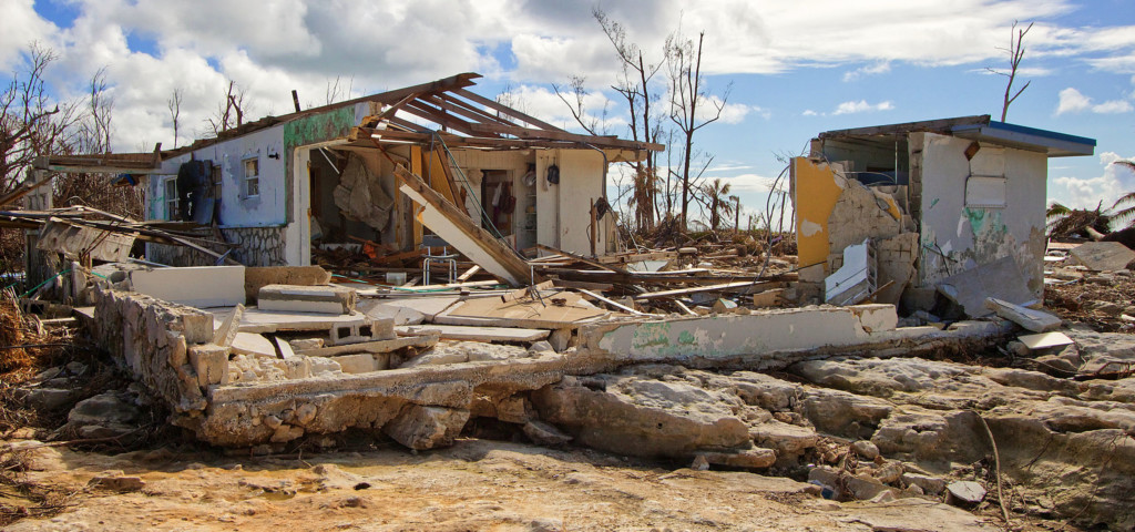
What Makes a Hurricane Deadly?
Storm Surge
One of the greatest threats posed by a landfalling hurricane is storm surge, or the increase in seawater level during a hurricane. Storm surges can be unbelievably deadly, and often lead to destructive flooding that can persist for hours or even days after the storm has passed. Large battering waves and the accompanying flooding can result in loss of life, destruction of property, and extensive erosion of beaches and coastal environments.
Heavy Rain
The amount of rain generated in a hurricane isn’t directly related to the hurricane’s strength, but rather the speed it travels, its size, and the geography where it lands. When heavy rain from a hurricane hits land, it often causes flash flooding of rivers and streams and, like the flooding produced by storm surge, this flooding can last for days after the storm itself has passed.
Hurricane-Force Winds
Another of the deadly threats that a hurricane produces is winds exceeding hurricane force (74 miles per hour or greater). Hurricane-force winds can easily destroy property, rip trees out of the ground, and transform debris such as signs, roofing and siding, and other items into airborne missiles. Winds can remain at hurricane strength even several hours after a hurricane makes landfall.
Tornadoes
Hurricanes can also spawn tornadoes when they come onshore. The friction that is generated when a hurricane makes landfall reduces winds near the surface, while winds higher up in the atmosphere remain strong. This creates a horizontal spin in the atmosphere, which can be then converted into vertical spin when it encounters a thunderstorm updraft. This vertical spin can sometimes lead to tornadoes, which can subsequently cause extreme wind damage.
Steps to Take Before the Storm
When staring down a hurricane, every second counts. Thankfully, there are some easy ways property owners can prepare for the upcoming storm season.
- Connect with a restoration partner to customize a pre-loss action plan and determine how to react should disaster strike. Devising a pre-hurricane plan is the most crucial precaution a property owner should take before disaster.
- Develop an Emergency Access Letter and Master Service Agreement so service providers can access the facility and restoration contractors can begin remediation work as quickly as possible.
- Prepare the property by making sure emergency supplies are in place, fuel tanks are full, equipment is covered, critical documents protected, data systems backed up, and evacuation routes and procedures are in place.
- Communicate the evacuation plan with employees and other residents to ensure everyone knows routes and procedures.
- Give critical contact info and directions to suppliers, vendors, and other partners so there aren’t any lapses in communication when time is of the essence.
- Determine if temporary power or a temporary facility is needed to reduce business interruption time.
- Provide instructions for shutting off water, power, and gas lines so any employee authorized can do so before the storm.
- Determine security needs such as camera monitoring, physical security, fencing, or boards for windows and doors.
- Track the weather and stay alert. Storms can move fast, so it’s important to stay updated on the latest conditions. Safety is more important than any property, so be sure to leave enough time to get out of harm’s way.
Share This:


